Chapter 1: India – Size and Location
Geography • Class 9 • Class 9 Contemporary India I
India – Size and Location
Saved in DatabaseGeography • Class 9 • Class 9 Contemporary India I
- India is entirely situated in the Northern Hemisphere, extending latitudinally from 8°4'N to 37°6'N and longitudinally from 68°7'E to 97°25'E. The mainland's southern boundary is Kanyakumari, while the southernmost point of the Indian Union is Indira Point (6°45'N) on Great Nicobar Island.
- With an area of 3.28 million square kilometers, India accounts for 2.4% of the world's total geographical area, making it the seventh-largest country. It possesses a land boundary of approximately 15,200 km and a total coastline of 7,516.6 km (including the Andaman & Nicobar and Lakshadweep archipelagos).
- The 30° longitudinal span results in a 2-hour time lag between Kibithu (Arunachal Pradesh) and Guhar Moti (Gujarat). To maintain temporal uniformity, the 82°30'E longitude passing through Mirzapur (Uttar Pradesh) is designated as the Standard Meridian of India, establishing Indian Standard Time (IST) at GMT +5:30.
- India occupies a strategic, central position at the head of the Indian Ocean, bridging East and West Asia. The protrusion of the Deccan Peninsula into the Indian Ocean facilitates maritime connectivity with West Asia, Africa, and Europe from the western coast, and Southeast and East Asia from the eastern coast.
NCERT Data Tables & Real-World Case Studies
- Indira Point Submergence: Located at 6°45'N latitude in the Great Nicobar Island, Indira Point served as the southernmost tip of Indian territory. During the December 2004 Indian Ocean Tsunami, the point was completely submerged under seawater, illustrating the vulnerability of India's island territories to extreme marine and tectonic events.
- The Chaibagaan Time System: In the tea gardens of Assam, a informal time zone known as 'Chaibagaan time' (Tea Garden Time) is observed. It is set one hour ahead of Indian Standard Time (IST) to optimize the use of early morning daylight, demonstrating a localized, grassroots adaptation to India's wide longitudinal span.
- Suez Canal Distance Reduction: The opening of the Suez Canal in 1869 bypassed the circumnavigation of Africa. This reduced the shipping distance between Mumbai and London from approximately 19,800 km to 11,600 km (a saving of over 7,000 km), which historically integrated India into the modern global trade network.
Mains Analytical Dimensions & Frameworks
Q: Analyze the geopolitical and economic significance of India's central location at the head of the Indian Ocean. How does this position shape India's maritime security strategy and regional integration initiatives?
Answer Framework & Value-Add Points:
An introduction should define India's geographical coordinates (8°4'N to 37°6'N; 68°7'E to 97°25'E) and its projection into the Indian Ocean via the Deccan Peninsula. The body should address: 1) Geopolitical Significance: Control over vital Sea Lines of Communication (SLOCs) and maritime choke points (Strait of Malacca, Bab-el-Mandeb, Strait of Hormuz); 2) Economic Significance: Access to major global trade routes, reducing transit times (e.g., the 1869 Suez Canal opening which cut distances to Europe by 7,000 km), and an Exclusive Economic Zone (EEZ) spanning over 2 million sq km; 3) Maritime Security Strategy: Transitioning from a 'brown-water' to a 'blue-water' navy, acting as a 'Net Security Provider' in the Indian Ocean Region (IOR), and countering the 'String of Pearls' through the SAGAR (Security and Growth for All in the Region) initiative; 4) Regional Integration: Active leadership in IORA (Indian Ocean Rim Association) and BIMSTEC. Conclude by linking this to Article 51 of the Constitution (promotion of international peace and security) and India's vision of a free, open, and inclusive Indo-Pacific.
Q: Evaluate the geographical and socio-economic arguments surrounding the demand for dual time zones in India, considering the country's wide longitudinal extent.
Answer Framework & Value-Add Points:
An introduction should highlight the ~30° longitudinal difference between Gujarat and Arunachal Pradesh, causing a 2-hour time lag. The body should present: 1) Arguments in favor of a dual time zone (e.g., 'Chaibagaan Time' in Assam tea gardens): Early sunrise in the Northeast (as early as 4:00 AM in summer) leads to a loss of productive daylight hours, increased electricity consumption in offices that open late, and disruptions to human circadian rhythms; 2) Arguments against dual time zones: High risk of railway accidents due to manual signaling errors at time-zone borders, administrative confusion in banking, aviation, and telecommunications, and potential political/social alienation of the Northeast; 3) Alternative solutions: Implementing 'Daylight Saving Time' (DST) seasonally, or shifting the office hours of Northeast states forward without changing the physical time zone. Conclude with recommendations from the National Physical Laboratory (NPL) which suggested introducing IST-II (UTC +6:30) for the Northeast, emphasizing the need for a balanced approach that prioritizes economic efficiency without compromising national integration.
Required UPSC Map Work & Atlas Pointers
Locate, trace, and mark these critical geographic coordinates/sites on your Atlas:
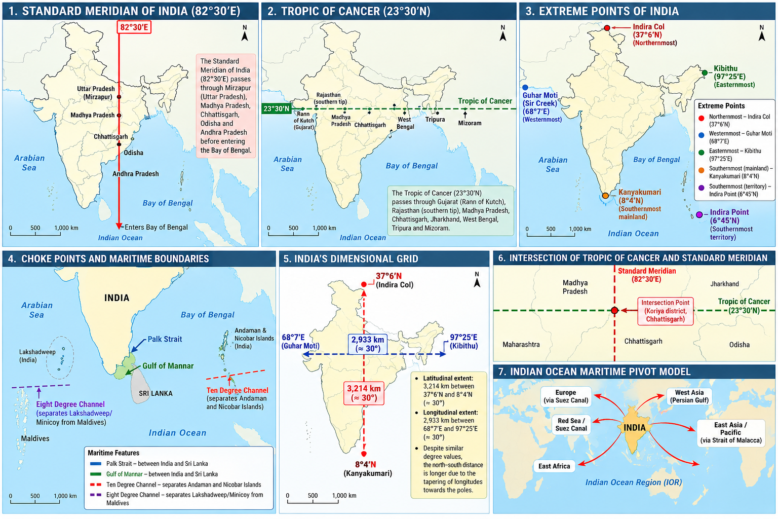
- Standard Meridian of India (82°30'E): Plot its path starting from Uttar Pradesh (Mirzapur), passing through Madhya Pradesh, Chhattisgarh, Odisha, and Andhra Pradesh before entering the Bay of Bengal.
- Tropic of Cancer (23°30'N): Draw the horizontal line passing through Gujarat (Rann of Kutch), Rajasthan (southern tip), Madhya Pradesh, Chhattisgarh, Jharkhand, West Bengal, Tripura, and Mizoram.
- Extreme Points of India: Plot Indira Col (Northernmost, 37°6'N), Guhar Moti/Sir Creek (Westernmost, 68°7'E), Kibithu (Easternmost, 97°25'E), Kanyakumari (Southernmost mainland, 8°4'N), and Indira Point (Southernmost territory, 6°45'N).
- Choke Points and Maritime Boundaries: Mark the Palk Strait, Gulf of Mannar, Ten Degree Channel (separating Andaman and Nicobar Islands), and the Eight Degree Channel (separating Lakshadweep/Minicoy from Maldives).
Diagrams & Flowcharts for Mains Answer Writing
- India's Dimensional Grid: A simplified outline map of India showing the north-south extent (3,214 km between 37°6'N and 8°4'N) and the east-west extent (2,933 km between 68°7'E and 97°25'E), highlighting that the latitudinal and longitudinal values are approximately 30° each, yet the north-south distance is longer due to the tapering of longitudes towards the poles.
- Intersection of Key Coordinates: A schematic diagram illustrating the intersection of the Tropic of Cancer (23°30'N) and the Standard Meridian of India (82°30'E) in the Koriya district of Chhattisgarh, showing the surrounding states as a spatial reference.
- Indian Ocean Maritime Pivot Model: A radial flowchart placing India at the center of the Indian Ocean Region (IOR), with arrows projecting outward to show maritime trade routes connecting to East Africa, the Red Sea/Suez Canal (Europe), the Persian Gulf (West Asia), and the Strait of Malacca (East Asia/Pacific).
Prelims High-Yield Explanations & Traps
- Tropic of Cancer (23°30'N) Spatial Distribution: Passes through exactly 8 Indian states from west to east: Gujarat, Rajasthan, Madhya Pradesh, Chhattisgarh, Jharkhand, West Bengal, Tripura, and Mizoram. Prelims Trap: Ensure you do not confuse Bihar, Odisha, or Manipur as states on this line.
- Standard Meridian (82°30'E) Alignment: Passes through 5 states: Uttar Pradesh, Madhya Pradesh, Chhattisgarh, Odisha, and Andhra Pradesh. Note that the Tropic of Cancer and the Standard Meridian intersect near Baikunthpur in the Koriya district of Chhattisgarh.
- Time Lag Calculation Mechanics: The Earth rotates 360° in 24 hours, which translates to 15° per hour or 1° every 4 minutes. The longitudinal difference between India's easternmost (97°25'E) and westernmost (68°7'E) points is roughly 30° (specifically 29°18'), resulting in a precise time difference of 117 minutes and 12 seconds (~2 hours).
- Coastline and Boundary Statistics: The mainland coastline is approximately 6,100 km, but when including the island territories of Andaman & Nicobar and Lakshadweep, the total coastline extends to 7,516.6 km. The land frontier (15,200 km) is more than double the length of the total coastline.
- Suez Canal Impact: Opened in 1869, the Suez Canal reduced the maritime distance between India and Europe by approximately 7,000 km, bypassing the Cape of Good Hope and transforming India's trade relations with the West.
- Southern Maritime Neighbors: Sri Lanka is separated from India by a narrow channel of sea formed by the Palk Strait and the Gulf of Mannar. The Maldives islands are situated to the south of the Lakshadweep archipelago, marking India's maritime boundary in the southwest.
Essential Definitions & Formulas
- Standard Meridian of India
- The central meridian of longitude (82°30'E) passing through Mirzapur, Uttar Pradesh. It is chosen in multiples of 7°30' (standard time zone intervals) to determine Indian Standard Time (IST), which is exactly 5 hours and 30 minutes ahead of Coordinated Universal Time (UTC+05:30).
- Palk Strait
- A narrow, shallow strait located between the Tamil Nadu state of India and the Mannar district of the Northern Province of Sri Lanka. It connects the Bay of Bengal in the northeast with the Palk Bay/Gulf of Mannar in the southwest.
- Territorial Waters
- A belt of coastal waters extending at most 12 nautical miles (22.2 km; 13.8 mi) from the baseline of a coastal state, over which the state has full sovereign jurisdiction, as defined by the United Nations Convention on the Law of the Sea (UNCLOS).
Chapter Maps & Diagrams
Map
Related PYQs (7)
Which of the following with reference to Indian States is/are not correct?